08.32

Kaliurang


Kaliurang In the early 19th century, a number of Dutch geologist who lives in Yogyakarta, the search for meaning for their family health. They are the areas north of the plateau. Sesampainya in Kaliurang located at an altitude of 900 meters above sea level, the "Meneer" is dazzled with the beauty and natural coolness at the foot of the mountain. They eventually build a bungalow, bungalows, and the area was decided as their health.


Pesona Kaliurang Natural History and Building

Travel to the direction of Kaliurang Jogja akan reminds us of the time on the paintings still in kindergarten. A mountain with a road in the middle and the green carpet extends on both sides of the house decorated, akan tired of painting in the frame of nature.

Be covered by cool breezes that blow, even in time mentari right in the head, it still feels cool. Dancing through the air and came down with the trees swaying, giving fresh feeling when body jump.

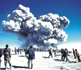
Landscape of Mount Merapi give distinctive sensation in this area. Like a village girl who deliberately close tabirnya when observed, this mountain will be closed when the fog as if ashamed deliberately come to view it.

Along the western Bukit Plawangan far 1100 meters, cross through a natural way, via the land diapit trees and lush hillside, row 22 caves heritage to become one of Japan's unique natural attractions Kaliurang.

In addition to the natural beauty, Kaliurang also has several historical buildings. Among them are Wisma Kaliurang and Pesangrahan Dalem Ngeksigondo Palace property was used as the place of the Commission of the Three Countries. Ullen Sentalu Museum or the part of the building is below ground. This museum reveals the mysteries of culture and values, history, and especially associated with the daughter of Yogyakarta and Surakarta Palace in the 19th century.

Family Recreation Area

Distance of 28 km from the city of Yogyakarta, Kaliurang now become an area of natural and cultural attractions that enchant, as well as a fun place for family recreation.

Relax with the family, parents can relax while supervising the children playing in the Park Recreation Kaliurang. In the garden area of 10,000 square meters children can play swing, perosotan, or swim in the swimming pool mini. In addition, in a garden decorated by a statue of jinn stories ala 1001 night and some this type of animal, children can also play mini-car or enter the mouth of a dragon sculpture that make up a small alley and ends at the ekornya.

About 300 meters to the northeast of the park there is a recreational Park Plawangan Turgo. Garden tour in the area there are pools of water Tlogo daughter comes from springs in the hill slopes Plawangan. Swinging or playing joke with the family playing in the park which is located in the garden tour, feeling tired akan dissolved in rimbunnya Perhutani garden.

Melangkahkan foot of the east side, some see the tails of monkeys swinging in berloncatan and limb, kicau enjoy the birds in the path berbatu bucket and ladder berundak on the road as far uphill 900 meters; may be a little tiring, but the scenery of Mount Merapi in the sunny time of Bukit Pronojiwo , will replace the tired feeling with admiration. On the way to the top of Pronojiwo, YogYES had fled compete with a foreign origin British tourist named Nick (47 years). Despite winning compete flee, but the feeling with the atmosphere ignites alamlah the most beatify. Drinking water is sold by the drink in a woman vendor can remove the top Pronojiwo while enjoying the feeling of thirst Merapi standing upright in the middle of a green carpet rimbunnya. Every holiday, Merapi can be seen through binoculars with the rent rate Rp.3000 for 30 minutes.

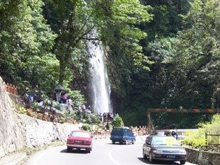
Sesampainya back garden to play in the location, at the moment bersantailah Tlogo Muncar. Ease weary while enjoying a dive in the water between the stones. Usually the water will flow with the downpours in the rainy season.

If you want to enjoy the Kaliurang, the visitor can get around using the train, known as rabbit sepoer term. This regular mangkal vehicle in front of the garden tour is filled with kiosks hawker food. Path that dilaluinya Kaliurang tour around the area from east to west. Passing through the depot view is located in the west, Merapi akan clearly visible when the weather sunny. Rates for a vehicle this Rp.3.000 per person if you ride at least seven people. To travel exclusive, travel Rp.20.000 akan make the withdrawal of a nobleman.

If you want to feel the fresh wind in the night and heningnya Kaliurang, many villas, bungalows, cottages or Pesanggrahan tourism can be an option. Charge also varies, ranging from 25 thousand to 200 thousand. Some of the lodging that you can enjoy, among others: Bukit Surya (most recommended), Puri Indah Inn (3 stars), Wisma Sejahtera, etc..

Before leaving make sure to bring a bit by the by-sold. Ranging from fruit production to local farmers' food that is typical tempe and tahu bacem and misbegotten (food made from rice sticky rice and grated coconut).

Green carpet at the foot of the mountain, the air cool and all natural luxury package, all akan ease fatigue and provide fresh from the urban hurly pikuknya.

08.27

Parangtritis Beach


Parangtritis Beach Located around 27 km from the city of Yogyakarta, Parangtritis is one of the beaches in Yogyakarta. This beach can be reached through the village Kretek or a longer route, but the scenery more beautiful through the village and Imogiri Siluk.


The beach is a sloping beach, with berbatu hill, coastal and sandy white. Besides popular as a recreational, Parangtritis also a sacred place. Many visitors who come to bermeditasi. This beach is one place to perform the ceremony of Labuhan Kraton Yogyakarta.

The complex consists of Parangtritis Beach, Parangkusumo, and The Highest Gembirowati. Parangkusumo there are swimming in the hot water bathing (sulfur), which is believed to cure various diseases in. Swimming is found and kept by the Sultan Hamengku Buwono VII. There is a complex craft shells, hotel International (Queen of South), and a gig tour in Parangtritis participate enliven tourism in the region.

Complex, which includes this area, namely: Petilasan Parangkusumo, The Parangwedang, The sheik Maulana; western, The sheik Bela Belu, Makam Ki Ageng Selohening, Place Fish Auction (TPI) Depok, Gumuk Sand (barchan).

08.23

Pandansimo Beach


Pandansimo Beach is located in the Village Poncosari, Srandakan District, approximately 20 kilometers southwest of Bantul. Located adjacent to the Progo River Estuary, and is the most west coast of the South Coast of the row into the region of Bantul Regency.


Deburan the big waves and the wild, mystical atmosphere that is still thick with the many sacred petilasan, hurly-burly fishermen fight against the waves ganasnya style attraction for tourists. Besides the beautiful beach panorama, Pandansimo on the beach, there are objects such as Pandanpayung pilgrimage tour and Pandansari. Interesting things you can do here is shop fish from local fishermen directly.


Pandansimo own name comes from the word "pandan (pandanus trees) and" Simo "(tiger). Here also there are various cultural events such as ceremonial tradition Merti Hamlet, Labuhan charity sea, and the boards of art and culture. Thus some small comfort in the middle of the pulse of life in the fishing beach Pandansimo. Self mambayar ticket entrance sign that average below Rp 2,000 per head, you can feel the pulse of life of fishermen simplicity.

08.20

Trisik beach

Trisik beach is a beach in Kulon Progo Regency akan found that when you go through the track Bantul - Purworejo, and pass Palbapang Srandakan. Located in the region Brosot, Kulon Progo Regency, around 37 kilometers from the center of Yogyakarta. Trisik Beach is located very close to the road so very easy to use personal vehicles.
Travel to Beach Trisik will feel comfortable and not so tiring though distance is far enough. The road to this beach is very fine and minimal rise, there are food stalls on the right path that is left can be a place of rest when tired. Beyond a path Palbapang and Srandakan, you can also enjoy the Progo river when passing bridges and Bantul Kulon Progo Regency.
Beach Trisik has uniqueness compared to other beaches in Kulon Progo, the rural atmosphere so that coastal feel. Beaches, houses of, gubug-gubug selling food and the way the village with the town located close together. Various activities that take advantage of the coastal and marine areas as a source of livelihood also meperkuat the coastal village atmosphere.
Place the fish auction is one place that will be found when entering the beach area this. This place is a heart for people Trisik who work as fishermen, because situlah activity in the sale and purchase of fish is on. Usually, this place is crowded right when fisherman since finished searching for sea fish
Eksotisme rural coastal fisheries as the world's daily akan found that up to you on the beach. Jejeran motor boats used to search for residents found can. Not far away, there are several nets into the show just finished used. Sejuymlah residents to open small stalls and stalls from gedheg-bagia few tourists who visit, selling drinks sekedarnya.
At a certain time, you can menyasikan boast a variety of birds in the air this beach. Believed, Trisik Beach is one of the port of migrant birds from various regions. Migrant birds, which can be viewed, among other trinil swamps, coastal trinil, trinil bushes, sandpiper red neck, wrinkle pot, kettle and a small necklace kite asia. Meanwhile, there are also birds such as non-migrant heron buffaloes, cows and swallow blue shrimp.
When you walk to the west following the direction of the asphalt road Glagah Beach, you will find other activities Trisik coastal villagers. On both sides of the road, you can see villagers using the hot sun in the beach area to drain the water hyacinth from the local residents Ambarawa.
Water hyacinth that has been dried is paid to the craftsmen made bags, slippers and a box. Results of normally distributed or paid to the city on the craft in the various regions to be processed more lanjuut. The craftsmen in the city usually do with the finishing process to add variety to enhance aksosoris. Although small in scale, the activity season water hyacinth is capable of giving the citizens.
With the feel of a rural coastal area so thick, of Beach Trisik very reasonable to include in your travel agenda. Not many have the feel of a beach that is still beautiful and simple as Trisik Beach

08.19

Cave Selarong


Cave Selarong is Area tourism object has a beautiful natural scenery and is suitable for use as Earth Perkemahan (Camping Ground). In the past, this cave is used as a guerrilla headquarters Pangeran Diponegoro in perjuangannya against Dutch colonialism in the year 18251830.

Prince Diponegoro to move to Cave Selarong after her home in Tegalrejo attacked and burned out by the Dutch.
Selarong cave is located about 14 km north of Yogyakarta precisely the direction in the district Pajangan and is in the top of the hill that much ditumbuhi guava tree, which is characteristic of the object.

Selarong in the vicinity of the cave there are centers that produce wooden handicraft statues, masks, and others. Government of Bantul Regency is developing the area as the object Cave Selarong with agro klengkengnya plants.

08.05

Breezy in the wind Losari Coffee Plantation

TIME Losari seemingly stop at Coffee Plantation, the former coffee plantation area of more than 22 hectares in Losari Village, Magelang, Central Java, which is converted into resort and spa at the end of 2003. Drive from Semarang direction to pass Ambarawa Magelang, in a place, turn the car to the left. Entering the lush countryside of the trees, suddenly feel like we are in a desolate place. Indeed different from the previous scene, the road almost all the time many large and small vehicles.

After passing through the wall along the white road, the gate tibalah Losari Coffee Plantation, located at an altitude of 900 meters above sea level. While the mountain breezes blow heartwarming breezy, with a natural background of Mount Merapi and vegetation greenness as if giving a "welcome".

Ancient buildings that have been renovated and is styled to be nyamannya such as lodging places tourists. So, what else should I say? Better not silence, enjoying the scenery, while menyeruput a cup of tea or coffee and warm titbit available there.

When you first go to places that are more than just lodging for the tourists - they may be more suitable place called berhening, restore the body's fitness after the tired didera busy working throughout the year - the guests will enter a building to which the Reception desk and lobby. Building a similar train station (KA) is a small building that was the train station from Mayong year 1878 that has been renovated again.

Guests will then be brought to the Club House, an ancient building that has also been renovated. Say, the building that was founded in 1828 by a Dutch architect, Van der Swan. Home furnishings with a wide tempo typical first make guests serasa in the past. In the library there are also small, which can be used to fill the front with a relaxing time while reading. Moreover, in addition to tables and chairs, where there is also a kind of bale-bale, which can be used to read the guests while back.

Near the Club House, there is the Plantation Bar. This building was a coffee warehouse storage after harvest. Now, in addition to the bar, where pool tables are available. Guests who stay there can take advantage to play billiards with friends.

There are more Joglo shaped building which is located somewhat in the middle Losari Coffee Plantation. The building, called the Java Red is a restaurant that serves Mediterranean cuisine and traditional cuisine, best cuisine from Indonesia. For those who want to enjoy fresh food prepared with spices from the garden in Losari Coffee Plantation, you can try Java Green in the pool is located.

Then, where guests stay overnight? Available not less than 26 villa / bungalows designed with architecture and interior design typical Java. In it there is a bed and other furniture which is a mix of antiques and contemporary art. Each villa has a balcony and the pages apart, bathrooms designed unique, and beautiful scenery to the plantation and the surrounding area.

That there is a swimming pool there are also unique. Octagon-shaped, water flowed from the river bottom land. No less interesting is the Hamam, a spa and bathing steaming hot Turkish style. The separate between men and women also provide a place for relaxation. Traditional Javanese massage with various spices as a spreader skin with a prescription that was believed to be thousands of years, also provided there. For the guests, also offered exercise and fitness through yoga holistic approach.

Of course, guests can not just stay, relax, and enjoy a variety of fitness programs available. Losari Plantation Coffee also offers package tours to different tourist objects near that place. For example, traveling by train to the ancient use of fuel coal. The locomotive was named Queen of the Mountain was made in 1902, will take guests to see beautiful scenery along the journey. Do not fear, for travel akan dihidangkan also food and drink. Travel begins from the train station to the Museum Bendono Ambarawa KA. At the museum, there are a variety of locomotive and train ancient gate that is still well maintained. Here, guests can also taste the pancake called a "pancake best" in Central Java.


bedroom villa in one of the

Package tour is a visit to Borobudur, the largest Buddhist temple in the world. Two other Buddhist temple that a straight line with the Borobudur, the temple and Mendut Pawon, will also be visited. In closing, invited tourists to visit the handicraft villages. Another way to enjoy the Borobudur Temple is at sunrise or when buried. Travelers can also try the elephant ride around the complex of Borobudur temple for two hours a day.

Still a matter of temples, a tour package is the next Gedong Songo temple complex in the area of tourism Bandungan, Ambarawa. There are also tours to visit the complex monument Dieng Plateau, which they say is built around 9th century BC. Of course, should not forget to visit Prambanan Temple, the largest Hindu temple in Java.

For those who like adventure in the open, the package provided a hiking tour to Air Terjun Sekar sky. Diverse flora and fauna typical of Central Java can be found here, even tourists can also try to swim in the river that have lasted for hiking.

No less interesting, tourists who stay overnight will be introduced to ways of making herbal medicine and enjoy a glass of fresh herbal medicine in the morning. In addition, there is a bid to see the coffee plantations that are still remaining in that place. Truly impressive.

07.05

G-Land / Plengkung

G-Land taken from the waves lake G, but the native called this place Plengkung. G-Land or Plengkung located in south east of Banyuwangi. Famous surfing camp is the G-Land. Plengkung beach is a popular place for surfers. Big wave from the Indian Ocean attract many surfer from around the world to this remote place - the best five surfing place in the world. Check the website for more information. Plengkung beach is in the area of Alas Purwo National Park. There are some cottages and camping ground, if you would like to stay over night.

G-Land is a most beautiful wave, fantastic jungle and extraordinary chalenge. A very special surfing destination of primitive beauty and perfect waves. This remote little camp on the edge of Plengkung Jungle in the eastern Java has earned a big reputation among nomadic surfers the world over. Like the primitive magical sound of its name, the mention of Plengkung is an Indonesian incantation that causes surfers everywhere to gaze off at the horizon. The long lines are unmistakably perfect and is regarded as the world's best left hander.

Plengkung, the pure white sand beach bordered on impenetrable jungle for as far as the eye could see, will give you the feeling of far from the civilized world. Plengkung is known as one of the best surfing beaches in the world, is said to be the paradise of the surfers because of its breathaking scenery and natural beauty. Plengkung usually call Surfer's Heaven, where surging challenges the big sound and famous rolling ocean wave which is 20 feet in height, 2 miles in length, and 5 minutes break in interval. The wave which is one of the best five in the world combine with beautiful sandy beach, cottages, tower and camping ground will be the best choice for a vacation. It is located about 88 km to the southern of Banyuwangi.

The only accommodation for miles around are the simple, elevated jungle huts used by the small community of surfers, who take advantage of the season which lasts from April through to October. Storms generated far out in the Indian Ocean give rise to perfect, kilometer long waves that reach four meters in height; every surfer's dream. The huts are equipped to accommodate about 20 people. You can spend the last hours of daylight exploring the beach and, as the tide receded, the exposed reef revealing rock pools filled with all manner of marine life. Soon you will find that you aren't the only one attracted and are soon joined by a flock of large sea birds, for which the reef is obviously a regular feeding ground. You, for sure will experience spectacular sunset over the bay.

Overland access to Plengkung is difficult and the normal route taken is via Grajagan from where visitors take the last stage of the journey by motorboat.

How to G-Land /Plengkung :

There are some simple cottages and a jungle camp available by the beach.
Recreational facilities
Plengkung is located on the south coast of Banyuwngi the eastest of Fast Java. The visitor can visit Plengkung overland. To reach Plengkung can be taken in two ways:

Overland. Banyuwangi-Kalipahit (59km)by bus Kalipahit Pasaranyar (3km) by ojek or rent a car, Pasaranyar-Trianggulasi (12km), Trianggulasi-Pancur-Plengkung/G-Land.

Overland-sea. Banyuwangi-Benculuk (35km) by bus, Benculuk Grajagan (18km) by bus or public transportation, Grajagan-Plengkung by speedboat,

Both ways to Plengkung are OK, if the visitors choose the second way, they can spend the night at Grajagan and enjoy the view before continue the journey to Plengkung.

07.04

Grajagan Beach

Grajagan Beach located in south of Banyuwangi, Only 30 minutes from Plengkung or G Land . Grajagan have smaller wave than G Land. G Land name taken from Grajagan, because G Land located one shore line with Grajagan.

Grajagan Beach completed with small motel, children play ground and other facility. Besides surrounded with mangrove, also surrounded with teak forest. So Amazing beach for you who dream the peace place. Grajagan is the second place for Surfing after G Land . Between beach, jungle, bay and fishing village. The collaboration can make we feel in the paradise.

Open-air recreation can be done in many places, such as: in forests, mountains, lakes, beaches, or combination of them. Grajagan is one of the Banyuwangi beaches that shows the combination of the rolling ocean waves on one side and the dense forest on the other one. In this place, we will be able to see the beautiful panorama of the Grajagan fishing village. Because of that, there are many tourists visit this place. It is located about 52 km from Banyuwangi. Here, you can find an old cave which was restricted by Japanese soldiers. If you want to stay, there are also available cottage, cafe, and playing area for chlidren.

This recreation place is in the region of KPH South Banyuwangi, BKPH Curahjati. It is 314 ha located about 0-20 m from the sea level. It is included in Grajagan, Purwoharjo, Banyuwangi. Its topography is plain with small hills. Its temperature is 20-28 degre

07.02

Ijen Crater

Ijen Crater is a part of Meru Betiri concervation. It is the biggest crater lake in Java. Besides crater, there are buffallo conservation, and amazing stone climb. Ijen crater on the top of Ijen mountain and give you the fantastic surround. From the top of maountain you can see all of Banyuwangi adn Situbondo area, also Bali Strait.

The sulfur crater lake lies between a natural dams of deeply etched rock. It is 200 meters deep and contains about 36 million cubic meters of steaming acid water, shrouded in a smelling swirling sulfur cloud. Inside the crater the different color and size of stones are found. Indeed the crater of Ijen is beautiful garden of stone as well.

The view of sulfur miners who climb and go down to the crater is also amazing. A man puts about I 10 kg of yellowish stone in to his basket, before he descends the mountain slope to sell his load, carrying the same basket, going in the same direction, digging the same mineral. It is the natural picture that can be seen everyday.

People arround of Ijen mountain belive that water from Ijen crater can threat the exim disease and also can make them look like young for along time.

Beautiful Mountain with a traditional sulfurs mine. It is also known as Ijen Crater (Kawah Ijen) as the mountain has a big crater lake (Crater = kawah in Indonesian language) The mountain can be reached from the city of Bondowoso, approximately 4 hours driving from Surabaya.

It can also be reached from Banyuwangi. Mount Ijen is located in one mountainous area together with Mount Raung & Mount Merapi (these two are active volcanoes). This mountainous area is also quite close to the Baluran National Park. Best time to visit: June - September Visitors must walk up to reach the summit. Warning: no smoking in the crater area! A new resort recently opened in this area – Ijen Resort & Villas.

07.00

Jatirono Natural Pool and Wonorejo Waterfall

If Yoo want peace pleace, Jatorono Natural Pool and Wonorejo Waterfall is the rigth place. Ambient by Cacao Park, on slope of Mountain, so peace and wonderful.

Jatorono Natural Pool and Wonorejo Waterfall are located at Kali Baru, west of Banyuwangi, about 60 km from Banyuwangi City. The Wonorejo waterfall is located at Kalibaru Wetan (East Kalibaru) on the slope of Mount Raung, while Jatirono Natural Pool is situated at the village of Kajarharjo. Those tourism places are at Kecamatan Kalibaru. The coffee, cacao plants are hampering the places. It is cool and beautiful place. Hotel nearest from both of place are Kalibaru Cottage or Margo Utomo Hotel.

06.58

The Savannah of Sadengan

The Savannah of Sadengan is located at south of Banyuwangi. This is a part of Alas Purwo and near from G-Land . About 25 km from banyuwangi city. Natives just call this please Sadengan.

Sadengan is the feeding ground for wild animals in the area of Alas Purwo National Park . The visitors can see the wild animals such as wild bull (Bos Javanicus), barking deer (Munticus Munoak), Wild Pig (Sus scofa), Peacock (Pavo Muticus), Jungle fowl (Galus sp) and many kind of birds. The wild animals are grassing and can be seen in the morning and afternoon from viewing tower.

Sadengan is location for pasture field was cultivated the grass lamuran. This area arround 80 Ha. In Sadengan there a tower for see the animal attraction which grass, for example Bull, Deer, Wild Pig of Forest and type – bird type.

Best time for the perception at 05.00-07.00 WIB and 16.00 - 18.00 WIB. All Sadengan's Visitor can use the vehicle to going to to park provided in order not to bother the wild animal life exist in pasturing field.

06.57

Watu Dodol

Watu Dodol is located at the village of Ketapang, Kecamatan Giri. Watu Dodol combinations of Hill, Forest and Beach east of Banyuwangi, East Java. You can see Bali from there. It is near the main road to the National Park of Baluran and Ijen Crater . The view is beautiful. The beach is stretching along the road and the hill on another. The visitors can see the island of Bali from it. A big stone stick between the main roads which called “Watu dodol”. Watu means stone and dodol is a kind of cake. The restaurants and motel are available here.

Watu Dodol Tourist Forest is a quite potential tourist destination in the Banyuwangi, East Java. It is about 14 km from Banyuwangi. This tourist forest is located within the protected forest, at an altitude of 10 to 50 meters about the sea level. Administratively, it is governed as part of the Pasir Putih Village, of the Wongsorejo Sub-District, within the Banyuwangi Regency.

This place is very precious. The combinations of hill, forest and beach make the beautiful scenery. Its beauty is more completed by a giant stone with a plant stands up in the middle of highway to Surabaya. The romantic panorama provides a good place for jogging track, cross country as well as enjoying the beauty of Bali strait in distance.

To the east of this tourist forest, and bordering the beach, a large boulder is standing 3 to 4 meters tall. A tree trunk is proturding from the south side of the boulder. At a glance, it seems that the branches are growing out of the solid rocks. While the larger boulder itself appears to rest on some other rocks. This is the characteristic that marks the Watu Dodol Tourist Forest.

A few meters east of the boulder; there is a platform that resembles a place of worship. At certain days the floor of this platform will be full of flower offerings, even small change.

Across the road, in the west, there is a cement stairways that leads to the mountains. About 10 meters to the right of this footpath is an ancient grave. It is at this ancient grave that visitors often meditate.

A bit to the north, there is a resting house complete with a seating arrangements. It is located exactly on the rock that hangs over the Bali Straits. The natural scenery from here is really fascinating. Further to the north are stretches of coconut plantation. The leave wae with the wind, while there is a lot of sea creatures, in particular sea shells. It is quite infatuating to visit the Watu Dodol Tourist Park. And if you look in the direction of the island of Bali (to the east), the Menjanagan and Tabuhan Islands at the edge of Bali Island are visible. So, when will you be visiting this tourist forest.

06.55

Baluran Park

Baluran National Park is located in south-east Banyuwangi. This a forest for animal conservation. It has a rich wildlife and maybe there are no other national parks that are so easy to visit and so easy to see wild animals. You don't even have to walk, unless you want to. You can find a lot of wild animal in their habitat at afternoon.

Efforts to get legal protection for Baluran started already in 1928 and in 1937 the area finally got its first kind of protection. Before it had been a hunting ground. In 1984 Baluran got its status as a National Park.

Baluran Park covers an area of 25.000 hectares including 40 km of attractive coastline. Forty percent of the park consists of savanna, teeming with wildlife. A part of the park is overgrown by Acacia trees that once were brought in as fire walls and spread out of control.

The coast line consists of mangrove forest, beaches and some coral reefs. The reefs are on a depth of 0,5m to 40m and nice for snorkeling and diving.

Rosa's Ecolodge has some snorkeling equipment available. The beaches are beautiful and family friendly and the only other visitors are an occasional fisherman or two.

Click to enlargeThe slopes of Gunung (mountain) Baluran are covered by secondary monsoon forest (very rare on Java) and are inhabited by many mammals and birds.

Even the very rare Javan panther is still living here. This 1.246m high non-active volcano dominates the scenery of the whole park.

The park is relatively small, but has ten types of ecosystems and hosts a wide variety and big numbers of animals and plants. At the last count 140 bird species were spotted.

Click to enlargeThe main attractions are the Javanese wild ox (Banteng), Rusa deer, Barking deer, Feral water buffalo, Asiatic wild dog, and other species.

Other common sightings are Leaf monkeys, Monitor lizards, Squirrels, Fruit bats, Javan warty pig, Common palm civet, and many interesting bird species. The Green jungle fowl, the Red jungle fowl, and the Javanese peacock are common sights for most visitors. The park was once also inhabited by the Javan tiger.

Lists of plants, mammals, birds, and reptiles can be obtained at Rosa's Ecolodge.

The park has an observation tower on a hill at Bekol and some waterholes where animals easily can be seen from a distance. The best way to see the animals is from a safari-car, especially at night.

The Park is managed by a government body called PHPA. A permit is needed to enter the park. It can be obtained at the main gate or at Rosa's Ecolodge. There is a Japanese bunker at the main gate dating from WW II.

Promoting Conservation

We actually promote conservation by financing the building of a drinking place for animals on the savanna raising conservation awareness of children by forming classes and by donating funds to the National Park.

06.54

Sukamade

Sukamade also known as Turtle Island or Turtle Beach is located south of Banyuwangi, East Java, and is part of the 55,845-hectare Betiri Meru National Park.

The best way to reach this beach from Denpasar, Bali is though Gilimanuk to Ketapang by Ferry and then with public transportation to Jajag-Pesanggaran-Sorogan and Sukamade. Visitors coming from Surabaya can reach the turtle beach through Jember and then Jajag-Pesanggaran-Sorogan and Sukamade.

Either way, the land journey takes about six hours.

Quite difficult to find public transportation to Sukamade. From jajag to Pesanggaran you can find Mini Bus, From Pesanggaran to Sukamade can reached by trucks “taxis”, they are also used for goods and produce. They are the only local vehicles that can negotiate the steep tracks and rugged roads leading to Sukamade.

The last stop before reaching the beach is the Sukamade home stay, from where a 300-meter walk through a mangrove forest and across Gethekan River will lead to the turtle beach.

Here in the vicinity of the home stay, the forest rangers and forest ecosystem staff maintain their offices.

This is also the location of the turtle egg hatchery, and all turtles that are successfully hatched are released back into the sea.

A heavy cloud darkened Sukamade Turtle Beach one evening in Banyuwangi, East Java, in early June. Stars could be glimpsed occasionally, but they soon disappeared as the clouds rolled across the sky and the beach turned black.

In the darkness, two rangers from the Sukamade Forest Reserve were on duty. They watched over the beach continually, because this is where the endangered and protected marine turtles come to lay their eggs.

The beach is the turtles’ maternity ward.

Sukamade Turtle Beach in Banyuwangi and Puger Beach in Jember used to be the two main locations in East Java favored by sea turtles for laying their eggs.

For some years now, however, the turtles have visited only the Sukamade beach, located 239 kilometers from the East Java capital of Surabaya. Almost every night, a turtle lands on the beach to rest or to lay eggs.

06.52

Tabuhan Island

Tabuhan Island located in north-east Banyuwangi, east Java, near from Watu Dodol Beach. Pulau Tabuhan is 23 km away from Banyuwangi with + 4 square hectares. Reachable by Benignly or public transport Banyuwangi Surabaya, stop at Kampe then by sailing boat or speed boat from Kampe beach.

The fantastic island is composed and surrounded by white sand. Coral seems to blossom into garden with an amazing variety of forms and colours. Growing coral from reef acts as homes for whole communities of marine life i.e. thousand of beautiful marine, aquarium fish species are Amphiprion the Dacyllus, the red coloured Labrida and the Gorisygula, shellfish, sponges, crayfish and marine plants. Any activities whether snorkeling or deep diving with breathing equipment exploring a reef and marine life in the spectacular drop offs are also an excellent under water visibility or sun bathing, an unforgettable experience.

Activities in Tabuhan Island
Diving, Fishing, Snorkling

06.50

Menjangan Island, One of The Best Diving Spots

As part of Bali Barat National Park, Menjangan Island is well known for its magnificent underwater world, beautiful coral reefs found nearby and best site for fishing. Another attraction of the island is the protected deer. Menjangan, an inhibited island about 10 km offshore, offers deep coral reef walls and is one of Bali's best diving sites. There are a few diving sites with good conditions and excellent visibility to choose from at Menjangan. It's also an interesting site for snorkelling. Menjangan also has a wreck, known as the 'Anker' because of its heavily encrusted anchor at the top of the reef. Fixed moorings have been built to prevent damage, and the island is reachable within less than 30-minute boat-ride from Ketapang Indah Hotel.

Pemuteran is an ideal place to start excursions to West Bali National Park, compromising the nature reserve of Menjangan Island and the uplands in the west. Menjangan has the most beautiful coral reefs in Bali; this is a wonderful place for diving and snorkelling.

West Bali dive sites typically offer pristine waters, colourful marine life and milder conditions suitable for divers of all levels. Divers who enjoy wall diving will appreciate the areas prime spots around Menjangan islands, but there is interest for every one here, with a deep wreck dive, some unique night diving, exceptional muck and macro diving near Lovina, and many snorkelling sites.
Most of the regents dive sites are found around
Menjangan Island. Diving is regulated here. Spear fishing is not allowed and all marine life is protected.

Menjangan' s white sandy beaches make a nice location to break for lunch. Underwater, the drop-off along the south shore and eastern tip, facing the
Bali Sea, are home to lots of colourful small fish and vertebrates, lacy sea fans and a variety of sponges. The sandy, gradual slope of Menjangan’s north coast is a final resting place for Bali’s oldest dive able shipwreck, the Anker Wreck.
Even large pelagic are sometimes seen at Menjangan. Occasional sightings of whales, whale sharks and manta rays have been reported. Drift diving is usual, but currents are quite mild and all levels of divers can enjoy this area.

06.49

Bayulor Private Plantation

It is a hidden private plantation, located in the foot of Mount Raung, ranges from 450-850 meters above the sea level. It covers approximately 748 hectares area. It is a beautiful scenery place formerly known as colony, which land is arranged by their own. The people live in six villages; they survive from abaca, coffee, clove, coconuts and spices planted. Here is your chance to experience the real life of the locals; no outsiders’ hands are involved.

Experience the hidden plantation estate with picturesque view on grassy track through the clove, coffee, and abaca plantation; including the coffee and abaca processing factories that are powered with water turbine installed in 1927 by the Dutch. Also, you can have a relaxation time while enjoying the locally grown coffee and local snacks in the waterfall viewpoint during the break and can be reached within 1.5 hours from Ketapang harbour.

06.46

Banyuwangi Regency, East Java : Meru Betiri National Park

Meru Betiri National Park covers 580 square kilometres (58,000 hectares) of eastern Java. It receives few tourists as accessibility is very difficult and the drive is a long bumpy trip, even by 4WD. The 30 kilometre trip crosses half a dozen rivers as it winds its way through dense forest and a runner plantation. As visitors near the park the potholes just get larger and the ride more unpleasant. It is perhaps unnecessary to point out how beneficial this is for the wildlife of the area. Named after the highest mountain in the area, Gunung Betiri, the park consists of one of the last large areas of lowland rainforest on Java. Amongst this are mangroves, lowland swamp forest and beach formations. It is from this reserve that continued reports of Javan tigers persist. These claims come from park staff and locals, but some experts suspect they are erroneous leopard sightings. In 1972 only seven Javan tigers were known to be Meru Betiri, and even as it was declared a reserve, (that very year), the area was under attack by agricultural development. A 1979 census located the tracks of only three tigers. Since that time all reports have been unable to be substantiated. It took until 1997 for the government to declare the area a National Park. These actions were far too late for the Javan tiger.

Experiments are to be carried out using infrared remote cameras as this would seem to be the only likely method of locating any tigers. Authorities are prepared to move several thousand natives from the local area if required. For these people the park provides honey, bamboo, rattan, wood, grass, food and 300 different types of medicinal plants.

Barking deer, wild boar, Banteng, sambar, Javan leaf monkeys, long-tailed macaques, pangolin, black giant squirrels, large flying foxes, reticulated pythons, Javanese eagles and water monitors all occupy the area. Felids at Meru Betiri include the leopard and the small leopard cat.

Conservation efforts are primarily concentrated on the nearby turtle nesting beaches, particularly at Sukamade, where the turtles are monitored and protected during egg laying. Green, leatherback, hawksbill, Olive Ridley and loggerhead turtles uses the same beaches.

Tagging of turtles has been taking place for some years. Together with the use of hatcheries, this has seen the populations stabilize and increase. Arriving between 9 p.m. and midnight, the turtles crawl determinedly up the beach, deposit up to 100 eggs beneath half a metre of sand and then return to the water; this takes some hours. Turtle Wardens collect the eggs and bury them where they will be secure from poachers and leopards. These big cats wait patiently in the hope of an opportunity to grab an easy meal.

Hatching takes two months, and if the hatchling survives the precarious 25 years to adulthood it may live to see 150. To increase the chance of survival the newborn turtles are collected and kept in tanks until they are stronger.

Meru Betiri National Park now faces ravaging by, not one, but by three separate mining companies. 80,000 tons of gold deposits have been found located within the area of east Java and three, possibly four, companies have joined forces for an application to mine the area. This has already been approved by local government officials who described the land as a local asset to be exploited by third parties. Before making their decision officials enquired about employment opportunities, data on the findings, and what income there would be for the region. There was no recorded mention of wildlife conservation.

06.10

Alas Purwo Plekung

Alas Purwo Plengkung and may be equated with the "case" Bali and Indonesia first. More foreign tourists to Bali of Indonesia. But Bali is part of Indonesia. So also is the case with Plengkung and Purwo Alas. Plengkung that are part of the National Park Alas Purwo far better known than Purwo Alas.


Alas Purwo TN map


Among the world peselancar, Plengkung also known by the name G-Land (Land G), refers to Tanjung Grajagan in Banyuwangi Regency. Grajagan known as the last place that can be achieved with the car to go Plengkung. From Grajagan, Plengkung can be achieved with the speed of the boat with about 30 minutes.

Now many routes Plengkung. The most simple, from the City of Banyuwangi Kalipait. Far as 59 km route is very convenient because of the way hot mix. From Kalipait, resumed the journey Pasaranyar villages along the road through three kilo meters. From Pasaranyar, proceed through the road trip makadam (berbatu road without asphalt) Trianggulasi go as far 12 km.

Trianggulasi from the Plengkung far as 11 km. Although there have been asphalted road, visitors are not allowed to use motor vehicles. Perforce, this route should be on foot for about 5 minutes. Could also be using the bike.

In the beginning no one knew that the beach is in the Peninsula Blambangan this potential to be one area that is in percaturan tourism. However, around 1970's, two peselancar from California, USA, Gerry Lopez and Mike Boyum, to try to feel tertantang violence wave in this region.


surfing in plengkung


Once terkesannya with waves in the beach Plengkung, they spread the news to several friends in California. Thanks to the information of both, since 1974 peselancar California who came to try a lot of waves Plengkung.

Finally, a quiet beach Plengkung, grew to be discussed many areas of the world peselancar. This region is ahead after the three private companies to establish lodging (more appropriately called the camp), namely PT Wana Wisata Alam Life is better known as Bobby's Camp, Plengkung PT Indah Tour and Travel PT Kenari. Proximity to the beach camp Plengkung only 100 meters to 150 meters.

Although the private sector managers and the food menu food classmates in five-star hotel, do not imagine camp semewah this hotel four or five stars, such as in Bali and Jakarta. Third camp managers want to keep Plengkung natural atmosphere.

"There is no electricity here, we use diesel. It's television, but please do not be watching RCTI, CNN or other television broadcast station. TV is only used to set the video, especially video on surfing. But a matter of food and drink, we do not lose with luxury hotels in Bali, "said Puma, Bali male supervisors who are in Bobby's Camp.

To spend the night there, the package cheapest Rp 385,000 per night, these Rp 550,000 per night. Cost is included for a T-shirt, boat speed freight, food and beverages. The difference, for these are equipped with a fan.

According to Puma, guests Bobby's Camp-is almost entirely peselancar professional, throughout the day, just surfing activities. From the camp in the stage and made of wood, the guests can lavish look to the beach and deburan waves coming from the Indian Ocean. If the good waves, they soon came down to surf. If the waves ugly, return to camp. So on. Best time to surf in Plengkung between May - October.

Tim Evans U.S. origin, is one of the peselancar stay at Bobby's Camp, have seven days to spend time in Plengkung. He is planning seven more days to stay there. After that, the Balinese, it was back to their home country. For him, as Bali is a place only in transit. He has more than 10 times the Plengkung.

Tim Evans claim to be living in such Plengkung because ombaknya good. One of the best in the world, than in Oahu (Hawaii), Fiji, and Tahiti. They are in the Pacific Ocean.

"If in Oahu, ombaknya large but short. G-Land has large waves, hard and long. Length pound could reach two meters high and can reach six meters. It's hard, not infrequently, a surfboard that we use can be broken. Challenges it sought peselancar sincere, "said Tim Evans.

Waves with a typical, no wonder if the series of the world surfing championship, Quiksilver Pro was held in Plengkung three times in succession, from 1995 until 1997. Unfortunately, the economic crisis, which was then followed by various disturbances, Quiksilver Pro for a while no longer held in Plengkung.

"I'm sure, if everything is safe, there is no commotion, the Quiksilver Pro will be held here again," said Tim Evans.

Although the claim to be living in Plengkung, lately Evans complained about the interference-interference due dibangunnya way to Plengkung. He is concerned, the road makes Plengkung easy to reach by other tourists.

"It is ten times more to me here, this safe-safe only. If everyone could easily here, I fear this place will not be safe. If you want to enjoy Plengkung, must take pains, if it does not want to walk, yes, should increase boat speed. The Beach Plengkung not suitable for swimming because there are some areas where the relaxing, "said Tim Evans.

Indeed, two years of development this way is very snappy Plengkung implemented. According to some information, along with the implementation of regional autonomy, the Government of Kabupaten (Pemkab) Banyuwangi industriously perform breakthrough-a breakthrough to improve PAD (original income areas). One of them is to develop the tourism potential that exists.

Plengkung that may be spelled virgin still be one of the target to increase Pemkab Banyuwangi PAD. To memuluskan target, the dibangunlah asphalt road to the beach Plengkung.


Although the exploitation Plengkung cause pro and contra, Plengkung still interesting to visit anyone, not just for professional peselancar. Along the way to the beach, the tropical rain forest that is still low and the object virgin tour of the area included in the National Park Purwo Alas, it is pity to miss.

In the travel Plengkung, can enjoy various kinds of tourism objects, such as scientific objects travel, land travel, air travel, tourism and culture. The, tourism object that is in the Alas Purwo is the most compared to other national parks.

Nearest beach is a beach Plengkung Pancur, about eight kilo meters north Plengkung. Here there is a camping ground (earth camp). In addition to camping and enjoying the beauty of the beach with the formation of black coral and sand shot, this beach is also a lot of people who visited bersemedi. Beach Pancur called because there is a river that flows throughout the year to the beach so that formed a steep shower.

Three kilometers northwest of Pancur, there Trianggulasi Beach. Trianggulasi name taken from the name of a monument, the Tugu Trianggulasi point is tied to the mapping which is located near the beach. This white sandy beach with the coastal forest dominated by tree bogem and nyamplung. On this beach, the sun sinking (sunset) is very beautiful.

Although the big surge, beach Trianggulasi can not be used for surfing, bathing, or swimming. For travelers who need a rest before continuing to travel Plengkung, this beach front home and provide for Pesanggrahan overnight.

Only about one and a half kilometers northeast of Trianggulasi, there are locations penggembelaan the different types of animals, namely Sadengan. From the perspective can be seen bison (Bos javanicus), deer (Muntiacus muntjak), wild pig (Sus scrofa), peacock (Pavo muticus), partridge (Gallus Sp), and several types of birds.

Not far from Sadengan, approximately one kilo meters to the north, there are Luhur Puri Giri Salaka, namely the Hindu persembahyangan number of people around the National Park Alas Purwo (District Tegaldlimo) quite a lot. Perhaps, this is a Hindu who embraces the descendants of the Majapahit fled to Blambangan Peninsula at the entrance of Islam.

This temple is very crowded visited the Hindu religion, especially in the Pagerwesi ceremony, ceremony penyelematan knowledge which the gods descended from the threat of giant pemangsa that lasted 210 days once. In addition to the people around the Hindu Purwo Alas, the ceremony also were Pagerwesi by Hindu people of Bali, Lumajang, and others in the district of Banyuwangi Regency.

In the ceremony, there is a procession of three, namely palemahan, pawongan, and heaven. Palemahan is offering to dispose of land to be eaten Betarakala. Pawongan a ceremony to receive the knowledge. While heaven is a sign of ritual thanks to the god who gave the knowledge.

About five kilo meters west Trianggulasi, there Ngagelan Beach, the beach landing where the turtle lay eggs and hatch. Compared Sukamade (National Park are Betiri) and Ujung Genteng (Sukabumi), Ngagelan no less stunning. Even in the case of many turtle species that lay eggs, Ngagelan more than Sukamade and Ujung Genteng.

"If the Sukamade, which lay only a green turtle. Ngagelan But in the four turtle species that lay eggs and hatch here. Ngagelan more complete. In addition, it is not uncommon that once lay in Ngagelan, will come again. It can be seen from taging I do it in the back, "said the diviner turtle, Suhadi Ponihadi.

Four turtle species that lay eggs and hatch in Ngagelan is gray turtle (Lepidochelys olivacea), star fruit turtle (Dermochelys coriacea), green turtle (Chelonia mydas), and shell turtle (Eretmochelys imbricata).

Blambangan still in the Peninsula, there is a small bay with a mangrove forest that is still virgin, that is Segoro Children. This place is suitable for water sports like water skiing, rowing, and swimming.

Children Segoro 18.8 kilometers long with an average width of 400 meters. In this place found many different types of birds such as parakeet, heron, blekok, jalak uren, and heron. At the time, the visitor can enjoy the rows of thousands of water birds along the coast line up Segoro Children. Birds are the migrant birds from Australia. To achieve Segoro Children, very easy. Can be achieved with four-wheel vehicle, about 11 kilo meters west to the defense post Rowobendo.

In addition to objects on the tour, there are still some objects belonging to a national park tour Alas Purwo which is located on Peninsula Blambangan, including Parang IRENG Beach, Pantai Batu Lawang, Tanjung Sembulungan (there is a lighthouse) and Wood Aking facing Selat Bali. Besides, there are about 40 cave, one of which is the famous Palace of Goa, the cave is very popular for meditation.

05.51

Sculp Eksotisme and Potential Natural Malang ( Balekambang )

Age of Malang Regency is older than the age of the Republic of beloved. However, until Anniversary Of Malang to 1248, most potential eksotisme and South Malang still with neat. Realize the 'New City' in the South Malang indeed take time. Slowly, and effective, Pemkab Malang chase started south of the Pearl.

Geographically, Malang regency long beach has a ± 57 km and has the potential of mangrove forest ± 8736 ha and pond area ± 8000 ha. Which extends in the coastal waters south of the store of a million eksotisme an irrefutable. Elegancy Balekambang coastal tourism and Ngliyep only real evidence of a small paradise in the south of Malang.

Beyond these two tourism object, along the southern coastal beach saving catenarian slick-looking nan who has not managed. Access road is still a major obstacle for the 'outsiders' to enjoy the loveliness of Malang Selatan. However, Pemkab Malang not only silent, slow start up nature of the potential to become a two-island of Bali.

Gateway to the 'New City' has been opened through the development of Southern Cross Line (JLS), which line the beach south slope. Channel into a major tourism development eksotisme natural wealth and potential of South Malang.

Based on data from the Department Binamarga Pemkab Malang, JLS phase I project along the 123 kilometer range start Mentaraman Village District Donomulyo to Hamlet Sendang Blue District Sumbermanjing Wetan.

Since 2002, Pemkab Malang has free land along the 63 kilometers, 22 kilometers of the property and community property Perhutani 41 kilometers. The process of redemption of land until the year 2007 the budget was up to Rp 11,878,084,300.

''At this time, the remaining land that is not exempt as long as 61 kilometers, is owned by both public and Perhutani. Sedanghkan than 63 kilometers of land that has been JLS free, just as long as 13 kilometers has not been opened or is done,''said the Head of Department Binamarga, Ir Mochammad Awar to Malang Post.

That is, at this time South Malang society can enjoy the JLS just about 1 mile from the beach from the mouth Donomulyo to the green bay Sendangbiru. Few illustrations, eksotisme extraordinary nature of these increasingly obvious Bajulmati after bridge built by the Government of East Java Province.


Semicircular bridge that connects tourism Bajulmati Beach and Bay Cave China that have water greenish.

Shifted to the end of the east about 3 miles, easy enough with the area of the fishermen Sendangbiru was affordable. The area was still the main center property beside the sea south of the potential nature reserve island Sempu.

Available RTRW (Spatial Planning and Regional Governance) Malang Regency, Sendangbiru that will be developed as an Urban Harbor.

Results while, at this time has awakened Place Fish Auction (TPI) in the southern part of East Java. Production of fish TPI Pondok Dadap Sendangbiru in 2006 reached 6,548 tons, 5,999 tons in 2007 and 2532 tons per year in August 2008.

To realize the project, share Pemkab Malang 33 districts in six SSWP (Sub-Unit Area Development). Among other Lingkar SSWP City (District 9), SSWP Kepanjen (District 9), SSWP Dampit (District 5), SSWP Overlapping (District 4), SSWP Ngantang (District Three). SSWP Sendangbiru and as the central sub-region in the three District Sumbermanjing Wetan, Gedangan and Bantur.

Meanwhile, the investment began filtering geliat, recently from investors, namely PT Bali Bali Fresh Tuna (BTS), ready to plant in the capital Sendangbiru to Rp 1.7 billion.

PT BTS will build cold storage for fish to see the potential that the area was dominated by Tuna Fish. Investment was also followed by Massa PT Reka field surveys that have been twice.

Investors from the island of gods is planning to make off road tours along about 20 km, from the beach Sendangbiru to the beach area in Ampelgading.

On the other Pemkab Malang to introduce tourism potential and natural, had Kanjuruhan Sabhawana Adventure Trail (KASATA). Motorkross annual expedition is always held on the Anniversary of Malang Regency with the challenging terrain that flit. KASATA followed by hundreds of off roader from within and outside the country with the concept adveture, tourism and culture

05.35

National Park Bromo Tengger Semeru

National Park Bromo Tengger Semeru has a sub-type ecosystems montana, montana and alphin with sub-trees that are large and hundreds of years.

Some types of plants found in the National Park Bromo Tengger Semeru such jamuju (Dacrycarpus imbricatus), mountain pine (Casuarina sp.) Eidelweis (Anaphalis javanica), different types of orchids and rare type of grass (Styphelia pungieus).

There are about 137 types of birds, 22 species and 4 mammal species in national parks reptilia this

Rare and protected animals listed in the national parks are mongoose (Pardofelis marmorata), deer (Cervus timorensis), long tail monkeys (Macaca fascicularis), deer (Muntiacus muntjak), forest red chicken (Gallus gallus), spotted tiger (Panthera pardus), ajag (Cuon alpinus), and various types of birds such as birds alap-alap (Accipiter virgatus), rangkong (Buceros rhinoceros silvestris), bido serpent eagle (Spilornis cheela bido), black srigunting (Dicrurus macrocercus), elang bondol (Haliastur indus), and grouse that live in Ranu Pani, Ranu Regulo, and Ranu Kumbolo.


National Park Bromo Tengger Semeru is the only conservation area in Indonesia, which has a unique form of the sea area of 5,250 hectares of sand, which is located at an altitude of ± 2100 meters above sea level.

Found in the sea sand seven central eruption in two lines that criss-cross from the east-west and northeast-southwest. From the northeast-southwest this is the show which includes Mount Bromo volcano is active at any time can remove the smoke and explosion threaten human life in the surrounding (± 3500 inhabitants).

Mount Bromo crater has a diameter of ± 800 meters (north-south) and ± 600 meters (east-west). While the danger area a circle with fingers 4 km from the center of Bromo crater.

Tengger tribe that is located in the vicinity of national parks is a native tribe who are Hindu. According to legend, the tribe of origin is from the kingdom of Majapahit into seclusion. Uniquely, the view around (Su-ku Tengger) does not appear to have a sense of fear although menge Mount Bromo-know-ya that berbaha, including many tourists who visit the National Park Bromo Tengger Semeru at the ceremony Kasodo.

Volcanic explosion in the peak of Mount Semeru


Kasodo ceremony is held each year (December / January) at the full moon. Through the ceremony, the Tengger tribe seeking to harvest the abundant or reject the request troops and healing of various diseases, including how to present the offering to throw the crater of Mount Bromo, Tengger while other people have to climb down cliffs and craters reach to catch the offerings thrown into crater, as the omen of the blessings of the earth.


Struggling attraction is offering a very interesting and challenging at the same time chilling. For the not uncommon among them, fell into the crater.

07.57

Air Terjun Lembah Anai (Sumatera Barat)


West Sumatra is a province of Indonesia. Geographically located on the fracture Sumangko, so that in turn makes the area has a lot of potential natural resources that can be used as tourism object. One of the many natural resources at this time to become a tourism and also maskot tourism in West Sumatra is Lembah Anai waterfall. Waterfall or a normal person Minang tajun an AIA or AIA mancua Lembah Anai is located along the path way between the trans Sumatra city of Padang and Bukittinggi.

Berketinggian a waterfall about 35 meters is part of the flow of River Trunk groove In the area of fracture Anai. By the local government Lembah Anai actually be a reserve area that functions as a provider of water, the administration of water (flooding and erosion), stable micro-climate, producing oxygen and penyerap CO2. However, as the impact of the tourism sector menggeliatnya ground water in many areas, which caused the others to maximize the potential for regional competition to attract tourists, some of the reserve area is finally made as tourism.

To enter the waterfall area Anai Valley visitor only be charged a relatively cheap, that is Rp1500, 00 per person. Next, if you want to be near the waterfall, it must be run again and the children climb some stairs and through some of the gazebo that used to rest. After reaching the location, visitors can listen to the sound of water while enjoying the natural beauty of mountains and a cool atmosphere and comfortable. And, for visitors who want to experience the beauty of voice gemericik the water at night, in locations around the waterfall area also available for camping.

07.56

Alam Mayang pond fishing


Alam Mayang pond fishing rod which is prepared as one of the destinations are Pekanbaru, Alam Mayang located on Jl. H. Imam Munandar, approximately 8 km from the center of Bukit Raya Pekanbaru District. Alam Mayang name means a fishing pond, or fish that is located in the 8 km road Harapan Raya, Kelurahan Tangkerang East, Bukit Raya District, Pekanbaru.

Here, three swimming available with a whole variety of meters and 18,560 species of fish such as fish gurami, fat, and indigo sepat Siam that we are ready to take home for the family. More fun, more fishing with the family because there is a swimming area in a small diner. Open every day the chance relax in the Alam Mayang and occasionally we tested the ability of competition in fishing. Not only is Alam Mayang Pekanbaru now also provide a place outbond such as image above.

Recreational destination this nature are very evident and even people from outside the city of Pekanbaru berekreasi there are also many, because the atmosphere is cool and comfortable to be used for various things and activities, not only for fishing.

07.48

Bukit Lawang


Literally meaning "door to the hills", Bukit Lawang is a small village situated 90 kilometers northwest of Medan, the capital city of North Sumatra, Indonesia. The focal point of village life here is the river running through the heart of it. In November 2003 in the late evening, a massive flood hit the village and killed at least 300 people. Described by witnesses as a tidal wave, the water was approximately 10 meters high, as it came crashing down the hills, wiping out everything in its path.
Although illegal logging in the area was initially blamed for the flood, the cause is not known, and many also believe this was just a natural disaster, Mother Nature’s way of revitalising the land. The village is on the edge of the magnificent Gunung Leuser National Park, which is an area of dense rainforest and home to the rare Sumatran orang-utans, as well as the Sumatran tiger and elephant, although sightings of these are also very rare. The people here live basically and the river is still where the women wash clothes, the men fish and the children play all day.
For many the trauma of losing family, friends and their homes has taken a long time to come to terms with, and after the tsunami and earthquake, many have been further affected due to having family and friends in nearby Ache. The people face unemployment, and homelessness. It has been a long road to recovery, and an expecially hard task to rebuild a town without financial assistance. The new village is now taking shape, as the people here are resourceful, salvaging what they can, however many are still homeless, and their health is suffering due to poor sanitation.
Since the charity was set up and registered in 2004, volunteers have raised thousands in funds, enabling us to buy rice and basic staple foods to feed the hundreds of families who were living in the bus station. We originally set up a small temporary health clinic, renting and refurbishing a building, and employing locals to renovate and employing a doctor, nurse, midwife and a manager. The clinic was run from this small house for two years, seeing more than twenty patients a day for free.
We have provided the village with water carriers, purifying tablets, sleeping mats, compost loos and educational materials. We have also held environmental education workshops where people learn about which materials are recyclable (plastic waste is a big problem) and the importance of protecting the jungle.
In March 2007 sixteen volunteers from Jersey travelled to Sumatra to build the new health clinic, which is now a permanent home for the Trust. The administrator, doctor, nurse and mid-wife moved into the new clinic in December 2007 and the clinic opened its doors in January 2008. A cleaner and new mid-wife and doctor have joined the team, and the plan is for the clinic to be open twenty four hours a day. The Trust eventually hopes to have ultra-sound facilities for new mothers and an ambulance running to pick people up from the surrounding areas who are too sick to be able to get to the clinic by public transport.

07.34

Tahura (Taman Hutan Raya Bukit Barisan)

Tahura Bukit Barisan Tahura is in the third set by a decree from the President of RI President No. 48 Year 1988 dated 19 November 1988. Tahura this development as a means of conservation of natural resources utilization and environmental improvement through the role and function of forests.

Bukit Barisan Tahura management unit is berintikan the area of protected forest and conservation area with all knowledgeable 51,600 Ha. Most of the protected forest is a natural mountain forest that is defined Dutch era, including Forest Protected Sibayak I Simancik and I, Forest Protected Sibayak II and II Simancik and Forest Protected Sinabung.

Other parts of the region Tahura this tersiri consisting of CA / TW. Sibolangit, SM. South Langkat TW. Lau Debuk-debuk and Earth Perkemahan Pramuka Sibolangit.

FLORA AND FAUNA

Forest area is dominated by the kind of good mountain tree species, both local and coming from the outside. Some types are: Pinus Merkusii, Altingia exelsa, Schima wallichii, Podocarpus sp, toona surei and other types such as Durian, Dadap, Rambutan, Pulai, Aren, Rattan, and others.

Types of plants that come from outside are: Pinus caribeae, khasia pine, Pinus insularis, Eucalyptus sp, Agathis sp, and others.

Some of the fauna that live in this area are: monkey, tiger, gibbon, wild pig, snake, eagle, small deer, treggiling, and others.

TOUR

Some of the Regions Tahura, especially around Tongkoh Brastagi and has developed into one of the important tourist destinations in North Sumatra.

The main factors supporting tourism as the air is cool, natural vegetation is good and the beautiful natural scenery, water source, Lake Toba and culture as well as the bait.
Besides, the infrastructure facilities are also sufficient, such as road conditions are good with the mulus, and which connects most of the area Tahura, accommodation and lodging facilities, camp locations and paths on the area.

Those interested in the world of research (research), Bukit Barisan Tahura can also be used as a warehouse of knowledge. Research is not limited to the areas of flora and fauna but also covers areas of hydrological and socio-cultural.

Lodging and accommodation facilities are spread around, from the Sibolangit up with a good lodging Brantagi simple and peg-star international hotel. As the main Tahura heart is in the Bukit Barisan Tongkoh.

In this Tongkoh lodging facilities have been provided, the primary room, library, restaurants, cultural stage, also aktrasi upside elephants, and animal quarantine facilities. In addition to tours, location Tongkoh also suitable for research activities, sports such as Cross Nature Tourism etc..

The people who live around the Bukit Barisan Tahura of ethnic Malay, Karo, Batak and Aceh. Main livelihood of farmers and laborers are. Production of vegetables is the main cabbage, bean, carrot, mustard greens, fruits such as oranges Tanah Karo is very popular so many fruit Markisa dikebunkan here and enjoy it in the form of syrup Markisa.

Local Government is very well in the development of this culture, for example, in a cultural exhibition in the Fruit Festival held each year and so on. Cultural preservation efforts, is also made to cultural heritage such as the custom house in Lingga.

Regions Tahura Bukit Barisan mountain has two, namely Sibayak Mountain (2,211 m) and Mt Sinabung (2,451 m), the mountain is often a challenge for the climber to menaklukkannya. It is recommended if you want to climb this mountain, ask permission first to the authorities, for the preparation of all things and the very existence of the required safety.

07.31

Berastagi

Berastagi is the main tourist destinations in the Karo Land located at an altitude of about 4594 feet above sea level and surrounded by rows of mountains, has a cool air from the carpet perladangan pertaniannya a beautiful, broad, green. Brastagi is a tourist destination that has a complete facility in the Karo Land, such as hotels, restaurants, golf and others, to the hotel can charge relatively affordable. Brastagi also known as the city's nickname "Markisa & Jeruk Manis".

From the city "Markisa & Jeruk Manis" Brastagi, the visitors will enjoy spectacular views over the mountains that are still active, namely Sibayak mountain climbing and mountain Sinabung.Untuk Mountain Sibayak take approximately 3 hours drive and we can enjoy the beautiful scenery in mountains, or take 3 to 4 hour trip in the forest to see the wealth in the natural flora and fauna in the forest around it.

Besides fruits, Brastagi also famous as the various types of vegetables, fruits and flowers. Brastagi in the city held several events tourism, among others, "Fruit & Flower Festival" and the cultural festival "party Mejuah-juah" is held every year. Tanah Karo is also a tradition that has been done from generation to generation that is "Year of Work" which is held every year by people who lived in the Karo district or who wander are coming back to villages that have family relationship to each other and visited bersilaturahmi.

07.15

Lake Toba

Lake Toba is a lake with vulkanik length 100 kilometers and 30 kilometers wide, located in North Sumatra Province, Indonesia. In the middle of this lake there is an island called Pulau Samosir vulkanik.

Lake Toba long since become a key tourist destination in North Sumatra, in addition to Bukit Lawang and Nias, attract domestic and foreign tourists.

History

Estimated to Lake Toba explosion occurred at around 73000-75000 years ago and is bursting supervolcano (super volcano), which is new. Bill Rose and Craig Chesner from Michigan Technological University estimate that the materials vulkanik a mountain dimuntahkan of 2800 km ³, with 800 km ³ ignimbrit rock and 2,000 km ³ of ash vulkanik estimated tertiup wind to the west for 2 sunday. Vulkanik be blown dust that the wind has spread to half the earth, from China to South Africa. Letusannya going for 1 sunday and throw debunya reached 10 km above sea level.

This incident caused the death of the bulk and in some species also followed by extinction. According to some DNA evidence, this eruption also menyusutkan number of people to around 60% of the earth's human population at that time, namely around 60 million people. The explosion also caused a time of ice, although experts still memperdebatkannya.


After the eruption, the kaldera form which is then filled by water and has become now known as Lake Toba. Pressure up by magma that has not come out cause the emergence of Samosir Island.